Video tutorial for creating a map in Ground Control, powered by Pix4D
Note: This video does not include Ground Control Point (GCP) use- for more info, please review this article
Tips on Collecting Data
Pilots collect data with the flight app, typically using an automated grid flight pattern with at least 60% overlap. Higher overlap settings help ensure data product quality, while also increasing flight times and the number of images captured. Detailed flight paths can be created directly within the Measure Ground Control (MGC) flight app or in the web portal.
Uploading Data
After data collection, images are uploaded to the mission page in the MGC web portal. JPG images are tagged in our system automatically and are ready for review and map processing. We recommend uploading your high-resolution imagery from a high-speed connection and avoiding cellular or latent connections. While Pix4D's cloud engine has a recommended cap of 4,000 images for processing and creating individual maps, we recommend starting with a max of 2,000. In terms of area, it's safe to assume if flying at 400 feet, you'll have 1 image/acre. So if your project exceeds that size, we'd recommend breaking it out into smaller image sets when creating the map.
Map Creation Permissions and Processing
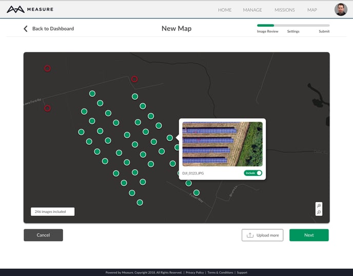
Map creation is restricted to users with the role of Admin or Data Analyst. The permission can be granted by your internal admin. When selecting to send images for processing, you will have the opportunity to review each image, along with its capture location, to confirm data quality prior to processing. Deselect any images you don't want to include, confirm the number of images to be processed, and submit.
Please note: This article assumes Ground Control Points are not available. For Pro or Enterprise users, please refer to this article for guidance on GCP usage
Data Processing by Pix4D
Images are processed and data products are created through seamless integration with Pix4D, the industry leader in photogrammetry. Processing time varies anywhere from an hour for small maps to more than 24 hours for very large maps in excess of 1500 images. You will receive a notification when processing is complete, and you’ll have the following data products to view or download:
- Orthomosaic
- Digital Surface Model (DSM)
- Contour Map
- 3D point cloud
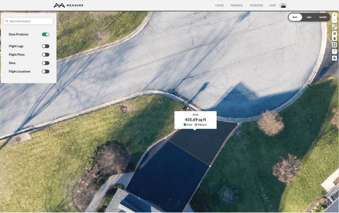
Viewing and Using Your Data Products
Ground Control’s built-in map viewer is an advanced platform for viewing your data products in 2D. You can search for a location, turn layers on and off, and create line and area measurements. Because we use one, continuous base map, you can also move easily among all of your data products and drone data by zooming in and out and moving around the map.
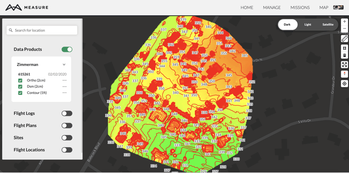
You can use the tools on the right of the screen to measure distance and area. You can also export your data products and other data layers for use in common GIS software platforms. Orthos and DSMs can be exported as GeoTIFF files while contours and flight paths can be exported as GeoJSON files.
Fly with Third Party Software
While we always recommend you plan to fly on Measure's web and mobile apps, we know sometimes this isn't possible. If you're flying with hardware we do not support or prefer to use apps like DJI Pilot, you can still upload the data for processing to Measure Ground Control. Regardless of the flight hardware and software you're using, make sure your drone is taking JPEGS, TIFF or TIF and you have sufficient frontal and side overlap.
Related Articles
Have questions or feedback? Please contact support.groundcontrol@ageagle.com