If your data/output is not in the format necessary/desired, here's how you can convert it.
GCP Input
Note: for GCPs, MGC currently only supports WGS84 (EPSG:4326)/EGM96 Geoid Orthometric heights (MSL). If you need to convert your XY coordinates or heights, please see the horizontal/vertical coordinates sections below.
Horizontal Coordinates
If you need to convert the X & Y locations for the coordinates of your GCPs into lat-long decimal degrees (WGS84)(EPSG:4326), Complete the following steps:
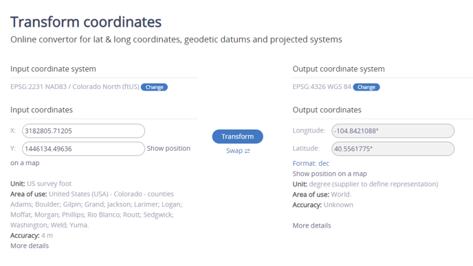
- Go to EPSG.io's transform coordinates page.
- Change the input coordinate system to the coordinate system used to capture your GCP XY data.
- If you have any trouble finding/selecting the correct coordinate system, you can also lookup EPSG codes at Spatial Reference.
- From here you can enter the EPSG code directly into the URL, and refresh the page. The page will update with the correct input coordinate system.
- Click Transform, and set the output format to dec. Your coordinates will be converted into WGS84!
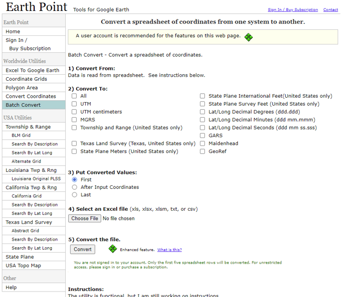
- Depending on what coordinate system was used, you may be able to also batch convert a list of your coordinates:
- Repeat step 3/do step 4 until you have converted all of the XY parts of your GCPs into WGS84.
Vertical Coordinates
MGC currently only supports EGM96 Geoid heights (Absolute height relative to MSL).
and not ellipsoid heights (geodetic heights) measured by a GPS, nor geoid heights (orthometric)(MSL) heights relative to a different geoid. Please ensure height values in EGM96 Geoid are the values being entered.
To learn more about elevation, feel free to check out this article.
If your elevation values are ellipsoidal, please complete the following steps:
- Ensure your XY coordinates have already been converted into WGS84 Lat/Long (See above).
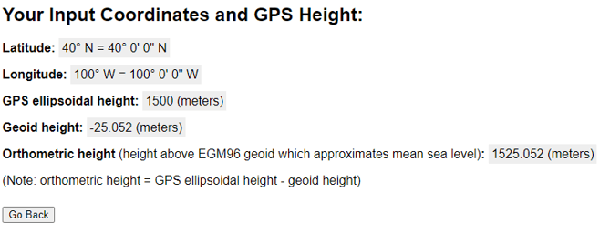
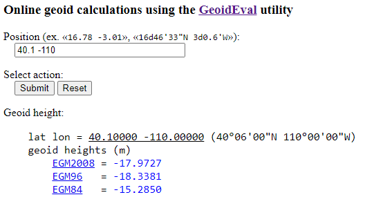
- Enter the Lat/Long for each of your GCPs on this website and your ellipsoidal height to get the height in EGM 96:
- If your ellipsoidal heights are recorded in feet/inches, they must be converted to meters. There are many free sites to do this.
- If your ellipsoidal heights are recorded in feet/inches, they must be converted to meters. There are many free sites to do this.
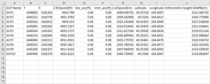
- You now have the orthometric height! We recommend using a spreadsheet to help keep yourself organized while converting values. Here's an example format:
Note: The geoid height is negative in nearly all of the continental US. Your ellipsoidal values should be lower than your orthometric (MSL) values if your data is from the continental US. - Your heights and horizontal/vertical accuracy must all be in the same units. If your horizontal/vertical accuracy measurements are in feet, you must either convert your orthometric heights to feet or your horizontal/vertical accuracy to meters.
- Now that all of your data is converted, you should be ready to submit! Submit the Latitude/Longitude, Orthometric height, horizontal accuracy, and vertical accuracy into Ground Control.
If your elevation values are another EGM geoid (like EGM 2008 or EGM84), but not EGM 96, please complete the following steps:
- Ensure your XY coordinates have already been converted into WGS84 Lat/Long (See above).
- Enter the Lat/Long for each of your GCPs on this website to determine the EGM offset:
- From here, take the offset value that matches your current vertical coordinate system (N), and add it to your orthometric EGM height (H), and that will be the ellipsoid height(h). In other words:
- h = N + H
- Apply this formula for all of your orthometric heights to get ellipsoid heights. Now that you have ellipsoid heights, convert your ellipsoid heights into EGM96 using the steps mentioned above (i.e. If you have ellipsoid heights).
If your elevation values are in another coordinate system, you may be able to convert your values using this page. (US datasets)
If you are still experiencing trouble, please contact support@measure.com.
Convert outputs
Note: All outputs downloaded will be in WGS84 (EPSG:3857)/EGM96 Geoid, with units in meters, regardless of the units displayed in Ground Control/Pix4D Cloud.
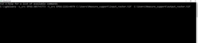
Orthomosaic Reprojection: If you need to reproject an orthomosaic you can do so in QGIS. Here's a video tutorial.
gdalwarp -s_srs EPSG:3857+5773 -t_srs EPSG:XXXX+ZZZZ <PATH>\<input>.file <PATH>\<output>.file
Related Articles
- Change display units in Pix4D Cloud
- Linear, Areal, and Volumetric Measurements
- How to use Ground Control Points (GCPs)
Have questions or feedback? Please contact support.groundcontrol@ageagle.com