Weather, advisories, restrictions, and other airspace information in the MGC Mobile App
As of August 2022, LAANC Authorization directly via Ground Control is unavailable. Please use the Google OpenSky mobile application to perform LAANC Authorizations on your mobile device while in the field.
Measure Ground Control features an embedded airspace map to keep users in the field updated on local airspace status, highlight restrictions and advisories, get weather updates, and even request flight authorization via the FAA's LAANC program. The airspace map is accessed by pressing the Airspace Map button on the main screen of the MGC Mobile App.
Using the Airspace Map
- Scroll by swiping the map in the direction you wish to move. Pinch to zoom in or out.
- Use the search bar to move to a specific location.
- The map will display the latitude and longitude of the location the map is centered on.
- Selecting the weather icon in the temperature to bring up weather details for the current location for the next 24 hours. Weather info includes wind speed, precipitation, visibility, dew point, and barometric pressure.
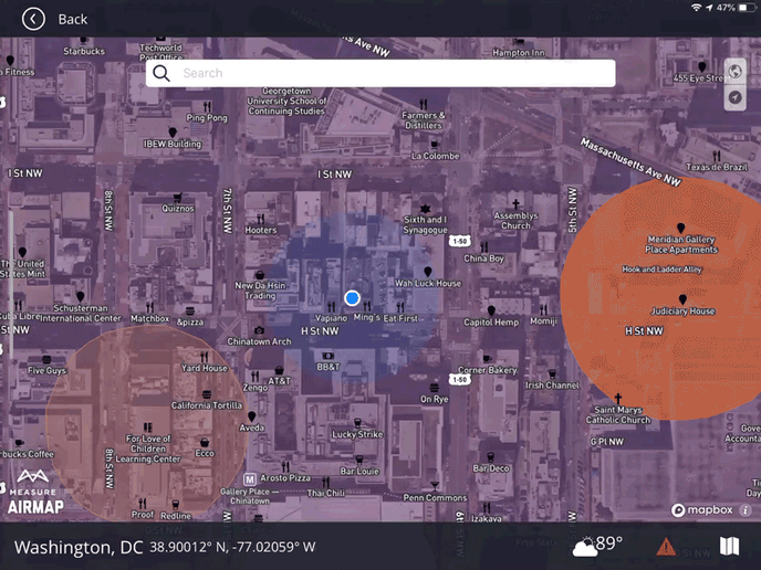
- Change base map layers and orientation using the map and compass toggle buttons in the top right corner of the screen.
Notifications, Rules, and Advisories
The Caution Icon in the bottom right corner will bring up the airspace advisories and restrictions for the map location. The icon will change color depending on the airspace:
- Green: Clear airspace
- Yellow: Warnings and advisories; be aware
- Red: Restrictions in place
In the advisories screen, users can change the rules they intend to operate under (Part 107, Hobby, 333 Exemptions), which will affect the operational profile of the airspace. Each individual advisory, warning, and restriction can be reviewed in detail by opening it in the drop-down menu. AirMap will shift what is displayed depending on your country of operation and its applicable aviation authorities/guidelines.
A key for the airspace overlay is available. To understand the different icons for the airspace map, click the folded map icon on the bottom right.
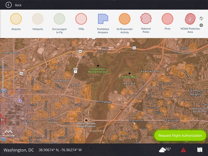
Airspace Legend
- Airports: Location of airports
- Heliports: Location of heliports
- Encouraged to Fly: Areas in which prior authorization was granted to fly, usually a group of hobbyists
- TFRs: Temporary Flight Restrictions, e.g. a stadium event
- Prohibited Airspace: A sensitive area deemed prohibited by a governing authority
- First Responder Activity: An area in which emergency personnel are actively working
- National Parks: Boundaries for national parks
- Fires: Real-time fire location within the US
- NOAA Protected Area: The US National Oceanic and Atmospheric Administration regulations prohibit certain flights of powered aircraft in these areas.
Related Articles
Have questions or feedback? Please contact support.groundcontrol@ageagle.com